It's that time again, I wonder how it came around so quickly!
I enjoyed 2009, 2 trips to Scotland and a few one night camps at home while not always going to plan were fun in retrospect. Thanks to all the other bloggers/readers out there I managed to drastically reduce my base weight, sometimes by reducing what I carried but unfortunately more often than not by spending more.
Who knows what 2010 will bring, I hope to continue getting my base weight down and hope if possible for 3 trips to Scotland. There are a few other unfinished projects, come to think of it there are a few that haven't been started yet.........
I'd like to thank everyone who commented on my posts, without discussion and the opinion of others a blog is just words. To those who visited quietly I hope you found something that made the journey worthwhile, if not I promise I'll try harder.
Special thanks to Ralph, Christopher and Marcus for joining me from time to time and to all I'd like to offer my best wishes for 2010.
One last thing. I couldn't let the old year pass without one last purchase. A Wenger Classic weighing 24g with cord to replace my 94g Victorinox Bundeswehr pocket knife and Camp folding scissors. That's if I can bear to leave my Victorinox behind ;-)
Thursday, 31 December 2009
Monday, 28 December 2009
Failure to Communicate, GPS pt.2
Arghhhhhhhhhhh!!!!
I've tried almost everything to get my GPS/Mapping Software to work but nothing.......
It seems the problem is that I can't enable a virtual Port (COM & IPT) in device manager. As far as I can tell when I load the driver/program to run the USB/Serial adapter it should set up a virtual COM & IPT port, I've tried installing/un-installing the driver (PL-2303 Prolific Technology Inc) and nothing. According to the install instructions once the driver is loaded plugging in the adapter only (no GPS attached) Windows should open the 'Found New Hardware' tab, then install the relevant information, then when I connect the GPS unit it should all work. It doesn't, only once did I manage to get the 'Found New Hardware' tab but connecting the GPS resulted in 'Unknown Device' and still no sign of a COM/LPT port in Device Manager.
I un-installed Quo in the vain hope that everything would sort itself out but no luck.
It's possible that my USB/Serial adapter is faulty so I'll get another which should come with a driver and I'll try again, I'm also going to get a Serial Card to see if I can at least get the Streetpilot 3 to work with Map Source as it's the priority unit, the hand helds can be replaced with USB compatible ones as a last resort.
Failure to Communicate, GPS
I've encountered a problem with my GPS units and mapping software since Saturday night when I was working with Quo/Garmin Geko. It seems my PC no longer recognises any of my GPS units and none of them work with any of the mapping programs I have installed in spite of the fact all were working perfectly.
I have 3 GPS Units, a Garmin Streetpilot 3 which was working with Map Source, a Garmin eTrex Summit which worked with Memory map and Quo and a Garmin Geko which was also working with Memory Map and Quo. All the units are designed to connect using a Serial Port but were working fine using an RS232 adapter which allows the data cable to be attached to a USB socket, I have to connect via USB as my PC doesn't have a Serial Port. Now nothing works, when I connect the units I get a variety of messages but all say pretty much the same thing, Windows doesn't recognise the hardware!!
I've tried un-installing the drivers, re-installing the drivers, system restore, disconnecting/re-connecting the units but to no avail, there's simply no communication.
I know that when using Memory Map the GPS unit communicated via Garmin Serial Protocol COM7 (port) and while I have a choice of 9 ports none of them can establish a communication. Using Quo and selecting Garmin Serial Protocol no ports are displayed and attempting to connect the Streetpilot 3 to Map Source results in similar messages.
I've tried everything I can think of apart from a full PC reformat which isn't an option. I've posted a variety of screen shots in the hope that somebody, somewhere knows what the problem is. If I can't sort it I'm left with 3 GPS unitsand 3 mapping software programs that are effectively useless. I don't have Windows Auto Update enabled so again I can't see how anything could have changed, I'm inclined to blame Quo as it's really the only thing that's changed but to be honest I don't see how it could have changed anything. Maybe I should un-install Quo to see what happens?
Saturday, 26 December 2009
Mapping Software for Northern Ireland
For a variety of reasons tourism, in particular the outdoors side of things isn't well catered for in Northern Ireland, there are a few areas of interest though with the most promising being the Mournes. It's not surprising then that Digital Mapping software hasn't been available from the major brands like Memory Map, Tracklogs etc.
Call it an unexpected Christmas present but I recieved an e-mail earlier in the week informing me that that Mapyx.com/Quo had released mapping software based on the Northern Ireland OS (OSNi)1/50,000 Discoverer series maps. The software is free to download and comes with a free XYZ UK Mainland map (1:1.000.000)
OS maps for Northern Ireland, the Republic of Ireland and Mainland UK can be purchased as sets or as 40 x 40 km tiles. Mainland UK is obviously better catered for with maps available in both 1/50,000 and 1/25,000. At present only 1/50,000 scale are available for N.I. but hopefully Mapyx can make the 1/25,000 scale Outdoor Leisure maps available in time.
I downloaded and installed the software and purchased the full set of OSNi maps which cost £39.99. The maps installed easily and initially looked good, the software being easy to use and fully compatible with my Garmin Geko 301. I did however run into a few problems some of which are easily sorted.
First the heights given were about 10m out, second there are no gridlines, third the searchable database feature didn't work and fourth, the coordinates given do not correspond to those found when using an official printed Discoverer map.
I posted a few question on the Quo forum and managed to find the answer to and the way to solve some of the problems. In addition to the actual maps I needed to purchase the OSNi 50k DTM (Digital Terrain Model) which sorted the height problem, and the OSNi Gazetteer which provided the information to allow the searchable database to function. These cost £7.99 and £4.99 respectively which brought the total cost to £52.97.
Unfortunately the coordinate issue is unresolved at present due to the format used by Quo. The Irish Grid format used is technically correct but isn't the same as commonly used in practice and on printed maps. When used on maps, Ireland (North and South) is split into 100km x 100km squares, each of which is designated (much like the British Grid) with one or two letters per square which results in a vastly different grid ref, for example, Trostan when using QUO is E318903/N424154 while on the printed map it is D179000/236000. In response to a question on their forum Quo have indicated that they intend to add the relevant information in a future update. I should point out that if I type a waypoint from an OSNi printed map into my GPS and upload the information the Quo displays the waypoint in the correct place, that said I'd much prefer to have the option of displaying gridlines on Quo printed maps which relate to official OSNi maps.
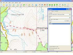
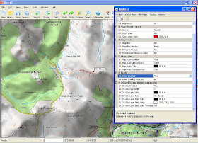
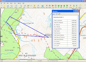
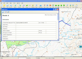
I haven't had a chance to try it out yet as I've been playing around with the various features, so far I'm generally pleased with it (apart from the gridline/grid ref issue). I've posted a few screen shots below which hopefuly will be useful.
Above. Using the 'Search' facility (Note Coordinates, OSNi map Coordinates would be 17900/23700)
Above. Relief Enabled, Accessed from 'Explorer Icon' on Toolbar.
Above. Route Summary, To Display, Right Click on last Waypoint and select 'Show Summary' from list.
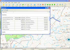
Above. Route Card pt 1. Information
Above. Route Card pt 2. Summary
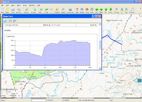
Above. Route Card pt 3. Gradient Profile.
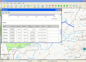
Above. Route Card pt 4. Waypoints
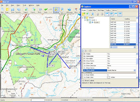
Above. Waypoint Information Displayed, Options Selected from Explorer Tab
Thursday, 24 December 2009
Sunday, 20 December 2009
Almost Got The Snow
I finally managed to make it out on Friday for an overnighter having had to postpone it for the past 2 weeks. As it turned out it was a day to early to get the snow, leaving for work this morning at 5.30 there was a good 5 inches.
Marcus was up for another wildcamp so we planned to leave about 1.30 on Friday afternoon aiming to be at Glenariff Forest Park by 2.00 which gave us 2-3 hours to head up onto the plateau on Upper Glenariff mountain and reach our camp spot near one of the many small lochs.
I'd packed my kit a few days previously and had planned to use the Alpkit PD200 Pied d'Elephant and ME Xero duvet jacket but I bottled out given the temperature and possibility of snow and took an Alpkit Filo down jacket instead. The remainder of my sleeping kit was made up of a Trekmates bivvy bag and combination of 2/3 season CCF mat and a Karrimor 3/4 Self Inflate bought for £10 in Sports Direct last weekend. I packed the Phreeranger Flysheet and footprint to use as a single skin tent and for cooking took my meths burner/cone/500ml pot set-up.
As far as clothing went I wore a Chocolate Fish Merino L/S top, North Cape Zip Neck mid base topped with an Mountain Equipment Ultrafleece jacket, trousers were Mountain Equipment Ibex and I decided to wear my Karrimor Pro Run trail shoes with Trekmates Gore-Tex socks and Horizon 50% Merino mix knee length socks. I also took a Montane Jetstream windshirt and wet gear consisted of Trespass Pack-away overtrousers, Marmot Essence jacket and Marmot unlined shell gloves.
We arrived at the forest park in good time and a short walk and climb on trail soon had us out of the forest and onto the open hill. The ground was frozen hard and made the walking easier and drier than normal and visibility was good.
At first we had to detour round a fenced off area but soon were on the middle of the plateau and heading east to wards the coast. Looking at the map you'd imagine that from a high point you would see most of the small locks but they tend lie hidden, only appearing briefly until you're almost on top of them.
Quite a few of the smaller, more sheltered ones were frozen over and it was interesting to try to remember the correct names as we reached them in turn. We had intended to camp on the east side of one of the lochs with a low ridge behind us as I'd expected the wind to come in from the East but as it turned out the wind had swung round and our sheltered spot wasn't going to be sheltered at all, the idea of an icy wind coming straight off the loch didn't really appeal to me and with light fading we settled on a reasonably flat area which provided better shelter.
I set up the Phreeranger but was a bit to careless and ended up with a slight slope down and back toward the porch, I could have adjusted the tent then and there but was keen to get a meal on and decided to let things be. That turned out to be a major mistake and one which I'd have plenty of time during the night to regret. Marcus pitched his Hike Lite 1 just beyond and we both busied ourselves organizing our gear.
I hadn't really tried the trail shoes much prior to this trip but was really surprised by how warm they were, the Trekmates socks worked perfectly and my feet were cosy even though it was cold enough to freeze the laces solid, in fact the ankle zips on my trousers were frozen. It was about this point when I realised I was going to have problems due to my poor choice of pitch. My groundsheet/footprint is silnylon and when I placed my sleeping mats on it they kept sliding sideways and back toward the porch area, this meant I couldn't cook in the porch but had to cook on the opposite side. That in itself wasn't a problem, what was a problem though was that every time I lay down I ended up in the porch with only the door keeping me from ending up outside. No matter what I tried I couldn't stop it and finally resorted to placing my rucksack against the door to wedge the sleeping mats in place and organised my sleeping bag/bivvy/duvet jacket combo but even so my feet always ended up pressed against the flysheet.
Making the best of it I soon had a meal ready, I was trying one I'd dehydrated myself, I've been trying it off and on for a few months now with very little success but on this occasion the meal was fine (Homemade Swedish Meatballs, sauce, carrot, cabbage and tinned baby potatoes) although I may have let it stay in the cosy too long as it had cooled down quite a bit.
I had taken an mp3 player to help pass the time and lay down and dozed off and on but wasn't particularily comfortable as any movement set the sleeping mats off. In the end I managed to grab a few hours sleep but feet were pretty cold as they kept coming off the sleeping mat or ending up pressed against the flysheet. In desperation I used the stuff sack that the Self Inflate mat was in together with the one used to pack my food as emergency vapour barrier socks, this worked fine up to a point, my left foot was toasty but my right one stayed cold, strange.
I expected it to snow during the night but there was only a brief flurry, even though there was plenty of cloud cover the temperature was below freezing resulting in frozen condensation inside the fly (a good thing) and a pair of rock solid trail shoes (not a good thing) although I managed to keep my water bottle mainly ice free.
I eventually got a few hours fitful sleep interspersed with brew ups and at about 7.30-8.00am I decided to have breakfast and strike camp. My shoes were frozen solid and I had a bit of trouble getting the laces loosened off enough to get them on but with some effort I managed and the gear was packed away as quickly as possible as I wanted to get on the move to get my feet warm. I had a bit of a wander around while Marcus had breakfast and packed up and my feet were soon nice and warm.
The sky looked leaden initially but soon the cloud dropped to cover the higher tops and at around 9.30 we started to make our way back, pretty much retracing our route from the previous day. I'd put on my waterproofs at the start and we hadn't gone far before we were hit with a snow/hail/sleet shower but the Marmot Essence was fine with no condensation.
As with the previous day the ground was pretty well frozen and with a bit of care we managed to avoid breaking through. The area marked on the map as dangerous for walking was fine but you could easily see how nasty it would be if the ground was wet as it would be in summer, the holes would be barely visible if the grass was higher and trying to find a route would be like trying to avoid crevasses on a glacier. As we neared the forest park the cloud began to lift and the sun tried to break through but he were hit with another short sleet shower as we made our way down the path to the foot of the Glen. A brief stop in a log shelter to remove overtrousers and have a snack/drink and we made our way out to the roadside where I'd arranged a pick up.
It wasn't a complete success but any failings were entirely my own fault. The gear I used was something I'd never have considered using in winter a year ago but worked perfectly well apart from a few monor inconvieniences. Firstly the groundsheet, I hadn't used it on it's own apart from in the garden at home which is flat therefore I hadn't considered the possibility of sliding out of the tent on my sleeping mat like some kind of eccentric bobsleigh rider (should it be driver?) I could have picked my pitch more carefully but what I need to do is paint some thinned down silicone sealer on one side to provide something for the sleeping mat to grip on. One other thing that could be improved on is my 'cozy' for rehydrating my meals, I used a single layer of Alu bubblewrap but I think I'll make one from closed cell foam or add a 2nd layer of bubblewrap to my existing one. Finally, although I'm not entirely convinced that the cold feet problem was caused by anything other than ending up against the flysheet I quite like the idea of a pair of down bivvy boots from PHD.
I didn't find the single skin tent to be a problem and the PD200/Duvet Jacket/Bivvy combo is something that I'm really pleased with, I mentioned previously that I'd ideally like a bivvy bag with sleeves and last night I discovered that Hilleberg make one, of course it's far too heavy at around 700g but as I don't really need a totally waterproof one I think I may be able to make something, after all it doesn't need to be Saville Row standard. The biggest surprise was the trail shoes, I only bought a cheap pair to try in summer and fully expected to regret using them at this time of year but they were absolutely fine, sure it would have been nice to pull on a pair of nicely padded boots 1st thing in the morning rather than freezing cold shoes but once on the move the shoes were the best option. That said I won't be abandoning boots, double skin tents or full Winter sleeping bags just yet, I'm quite happy to push things a little on a one nighter but for a longer duration trip I'd err on the side of comfort/caution.
I still need to work on my baseweight as it was 7kg and I'd like it closer to 5kg given that I was using a fairly stripped down gear set for a conventional camper, looks like a lighter shelter is needed but what? I'm pretty sure about a new pack though, I need to do a bit more research but the ULA Ohm is top of the list so far.
To quote Steve Earl, "We ain't Never Satisfied" ;-)
Friday, 18 December 2009
Groundsheet on the Inner Tent, why?
I never gave it much thought before but looking at the various Tarptents from Henry Shires I got the idea that you could easily add a floorless inner tent to create a double skin tent, in fact Henry provides something similar, a Clip-In Liner for the Double Rainbow.
That got me thinking about double skin tents in general, why have the groundsheet and for that matter the mesh doors attached to the inner tent? Imagine if the groundsheet and mesh was permanently attached to the fly to which you added the floorless inner. You could use it as a single skin with full groundsheet and midge protection if you wanted to reduce weight and simply add the inner when needed.
There doesn't seem much to be gained by attaching a groundsheet, which will probably end up wet and muddy, to the inner tent which ideally you want to remain clean and dry but thats how every tent I've ever seen has been designed, any ideas why this is? wouldn't it make more sense to have the fly/groundsheet together as both are likely to be wet anyway.
The best reason I can come up with is that maybe historically tents were canvas/cotton with a sewn in ground sheet to which they later decided to add a nylon waterproof 'Fly' and thats how they've remained, just conventional. Is there any logical reason why it couldn't be done the other way?
Thursday, 17 December 2009
Single or Double?
I've been considering whether or not to go for a single skin shelter but it seems that I've ended up with more questions than answers. The primary reason for going 'single skin' would be to reduce weight and there are various options but generally speaking they fall into 2 categories, tarps or tarp tents, again there are 2 main types of tarp tent, those like the Henry Shires 'Tarptent' single skin range with sewn-in mosquito net and those that require the use of a separate net.
What I've found is that if you look solely at weight by the time you add a separate net to a single skin tent you can end up with something heavier than a lightweight double skin tent which rather defeats the object in my case. That said you seem to get more space for a given weight using a single skin/bug net combination.
With that in mind I'm drawn to something from Henry Shires, the Contrail, Rainbow or Moment to be exact. The Contrail is the lightest at 696g followed by the Moment at 810g and the Rainbow at 965g. I like the weight and width of the Contrail but it looks susceptible to side winds and also looks like it could flatten at the tail, the Rainbow is also likely to be effected by side winds but I like the layout although it's about 25% heavier while the Moment looks like it would be the least effected by changes in wind direction, isn't much heavier than the Contrail but looks a bit narrow at the head and foot.
Of course there's always the question of the Scarp 1, would it be better to just use it at 1250g and have an all season fully featured double skin tent? It would seem so as my base weight for tomorrow night is currently sitting at just under 5550g, about 1300g of which is my Phreeranger set-up as a single skin, if I used a Contrail it would be about 4950g but using the Scarp 1 would mean I didn't need to take a bivvy bag at 305g which would leave me with a base weight of approx 5200g with the benefit of a double skin tent. To really benefit from a single skin I'd need a lighter bivvy bag, e.g the Titanium Goat Ptarmigan at 193g which with a Contrail would give me a base weight of about 4833g.
In the end it's just under 400g difference between a Contrail based set-up and a Scarp 1 set-up and that makes for a very convincing argument in favour of the Scarp 1 if my primary reason for considering a single skin is weight. As it is there are 3 areas where I can save weight, Shelter, Bivvy Bag and Rucksack, I'm interested in the ULA Ohm which would save me over 400g on my current pack, the Haglofs LIM 45. That may well be my next purchase, I like the style of the Ohm and if my calculations are correct it's a little smaller than the LIM 45 which would be perfect as I can almost get my gear into a Karrimor Hot Rock 30
As I said at the outset, after considering the options I'm left with more questions than answers although tomorrow night may help fill in the gaps (if the weather forecast is correct) as far as single skin shelters are concerned. It hasn't been a complete waste of time though as I'm pretty certain I know what my next pack will be.
Sunday, 6 December 2009
Rain Gear, Part 2, Trousers
While I may have spent too much looking for the perfect waterproof jacket I haven't had the same problem with regard to overtrousers. I have a pair of Berghaus Extreme 3 layer Gore-Tex ones with full side zips that are as old as my Phoenix jacket. I bought the full zip type so that I could put them on while wearing skis and while they can be a bit of a handful in a breeze they work well. I haven't had much call to use them in recent years so they're still in pretty good condition apart from the odd stain caused by wax.
Of course when I starting kitting out again I wanted to get something lighter and by chance found a pair of light overtrousers in my local Trespass store. I think they're the Trespass'Prusik' model made from coated ripstop type nylon, the coating/fabric being branded as Trestex. What I liked about them apart from the price was that they had almost full length zips which makes them easy to get on/off over boots. The zip is double ended which allows me to vent them if required and has both internal and external stormflaps, the outer one closed with velcro patches, the waist has a simple shockcord and cordlock. I consider these my winter overtrousers and so far they've proved to be both waterproof and breathable. They pack down nice and small, weigh 299g and if I remember correctly cost around £15 in the sale. They're not the lightest available but you can pay much more for very little benefit, breathabilty may potentially be better in more expensive brands but I feel that condensation is less of an issue in overtrousers, in any case I haven't noticed condensation in these.
While being pleased with the Prusik's I still wondered if I could reduce the weight but found it difficult to reduce it significantly without spending quite a bit. The obvious answer was to look for something for summer use, basic overtrousers would be fine as hopefully they wouldn't be needed too often (Whatever gave me that idea!) so I went back to Trespass to look at the really basic Trespass Packa range. I found exactly what I was looking for, basic overtrousers in plain breathable coated nylon, again branded as Trestex with simple stud fasteners at the ankle. I paid around £10, sale price again so no complaints there. There was one small problem though, they have vents to allow access to your trousers pockets (2 front, 1 back) but they can't be fastened shut with the result that when it was breezy they allowed rain to enter and inflated like a balloon. The easiest option was simply to seal them on the inside with duct tape although I could sew them closed and seal the stitching as I would a flysheet using silicone sealer thinned with white spirits (I could possibly glue them shit using silicone). I wore these on my last overnighter and in spite of tramping through and falling into peat bogs and wet heather they performed really well being both waterproof and breathable, I was wearing lightweight Columbia Omni trousers and any lack of waterproofness or breathability almost certainly have been apparent. These pack even smaller than the Prusiks and are half the weight at 150g. Personally I think they're both great, they've worked well so far and if they get damaged it isn't going to cost much to replace them.
I think it's easy to overlook the cheaper brands and it was only by chance that I found them but sometimes you can find perfectly servicable products at a really good price by looking at the item rather than the brand name. I don't mind paying for a top end product if there isn't an alternative, it's virtually impossible to get a light, warm sleeping bag or duvet jacket for example without spending serious money but in the case of the over trousers I probably saved between £50-£100 and thats money that can be better spent on other kit where there isn't a low rent alternative.