
I was out for another short walk with Les on Tuesday, this time we decided on a walk in Slieveanorra forest starting near Altnahinch reservoir. The River Bush has its source just above the reservoir and flows into and out of the dam on its way to the sea at Port Ballintrae. The Bush is famous as a Salmon River and also as the water source for the world famous Bushmills Whiskey distillery which is situated in the North Antrim village of Bushmills.

The weather wasn’t promising with rain forecast for most of the day and when we started off on the forest track it was raining heavily although there was no wind. We both had some new gear which was getting a 1st outing, in my case a pair of Keen Gorge neoprene canoeing/water sports boots while Les had picked up a Berghaus waterproof jacket and a Lowe Alpine day sack.

The rain was relentless and visibility poor as we made our way through the forest so when we reached the point where we had to decide on going to the summit of Slieveanorra or doubling back towards the reservoir we decided on the reservoir. All the small streams running through the forest were in full flow and in a few other places where they’d exceeded the capacity of their normal route they’d taken the path of least resistance on their way down towards the reservoir.


Not having taken a map I discovered one of the limitations of relying on a hand held GPS even though it has maps installed. Although the Lowrance Safari is waterproof the screen is barely readable when wet so when we reached a junction that led off in the direction we wanted to go we took it. Unfortunately it led to a dead end and while we may have been able to bushwhack our way through, the trees were quite young and consequently close and we couldn’t discern sufficient detail on the GPS to be sure exactly what direction to take or how far we’d have to go to break out of the densely wooded area, as it was still raining heavily the prospect of forcing a way through thick wet undergrowth wasn’t particularly appealing. The correct choice was obviously to back track and take the other path which we did.

We continued along the track before taking to the forest for a bit and when we emerged the cloud had lifted sufficiently to be able to see the Wind Turbines on Slievenahanagan on the other side of the glen. As the cloud lifted the rain eased off and by the time we’d left the forest and reached the road it had stopped completely.

We only has to walk the road for about 1.5km to reach the entrance to the reservoir but there was enough to see in the way of wild flowers, another unexpected find was an old railway carriage. I’ve seen old railway carriages before in places were there aren’t any railways, disused or otherwise so I assume that they were sold off and bought for use as sheds, this one looked like it might have been used as a potting shed but who knows.


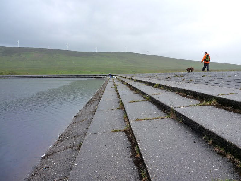
As soon as we reached the reservoir, one of the last to be built in Northern Ireland and completed sometime in the late 1960’s we took to the path and walked down to the foot of the headwall, it’s a small reservoir but interesting nonetheless. In spite of living close to the reservoir I can’t remember being down at the outflow before so it was an unexpected bonus and one that I wouldn’t have had if the weather had been better. From the foot of the headwall there’s a steep grassy slope up to the reservoir itself, about halfway up a wall runs to the top, on one side the wall is only about a metre high but on the other side there’s an ever increasing drop, it was along the top of the wall that I decided to test the grip of the Keen Gorge boots but as the drop to my left increased I decided that discretion was the better part of valour and jumped off (to my right), in any case they felt secure enough.


Once up at the reservoir we discovered a few guys fishing, the reservoir holds native Brown Trout but is also stocked with Rainbow Trout from the Movanagher Fish farm situated on the River Bann, in fact we passed the fish farm while at the lock gates at Movanagher on our Easter canoe trip. From there it was only a short walk along the road again to the car.
Again another interesting walk, something different and as I’d just picked up a copy of Irelands Wild Flowers I was happy to get some photographs for identification later.

really good shots here, and a nice bit of history. Good idea to photograph stuff for ID later.
ReplyDeleteI am always interested in people's thoughts on GPS units. After a brief but unsatisfying daliance with one a few years ago I have since gone back to paper maps. Admitedly though I use the waterproof variety (which are hardly lightweight!)
ReplyDeleteI see more and more people using them on the hills but I always find them hard to "read" or follow
Personal choice I guess. Where GPS units really come into their own in my opinion is when you want a rid reference eg when in heavy mist just to sense check you are where you think you are on the map!
@David, I should have some slides that belonged to my Dad of the dam being built, my intention is to add them if/when I find them.
ReplyDeleteAs for the wild flowers hopefully I'll be able to i.d. them without the book eventually :-)
@Dave (Backpackbrewer) I'm not entirely convinced by GPS, they're useful but can't replace a paper map, one thing is that they're (at least the Lowrance Endura) difficult to read in bright sunlight, equally difficult when it's raining and they don't show a wide enough area. Useful for spot checks certainly but my Garmin Geko does that just as well as the Lowrance. The main reason I bought the Lowrance was that it integrated with my Mapyx Quo software and AFAIK Quo are the only ones doing OSNI maps. Normally I'd have printed off a map of the area but hadn't bothered this time.
It may be worth a post sometime.