Showing posts with label Camping. Show all posts

Saturday, 30 April 2011

Lower Bann Canoe Trail, Day 2


Having had to abandon the hammock due to feeling cold I'd eventually got over to sleep in the bivvy bag but wakened at around 5.30am as the sky started to lighten. As everyone else seemed to be sleeping soundly I turned over and fell asleep again wakening at around 7.30am with the sun now shining brightly and sunlight filtering through the trees. Not quite ready to emerge from my sleeping bag I filled the Backcountry boiler and grabbed some twigs that had been laying under the upturned canoe and boiled some water for a cuppa. Ralph emerged from his hammock just then so we both had a cuppa and a wander around.


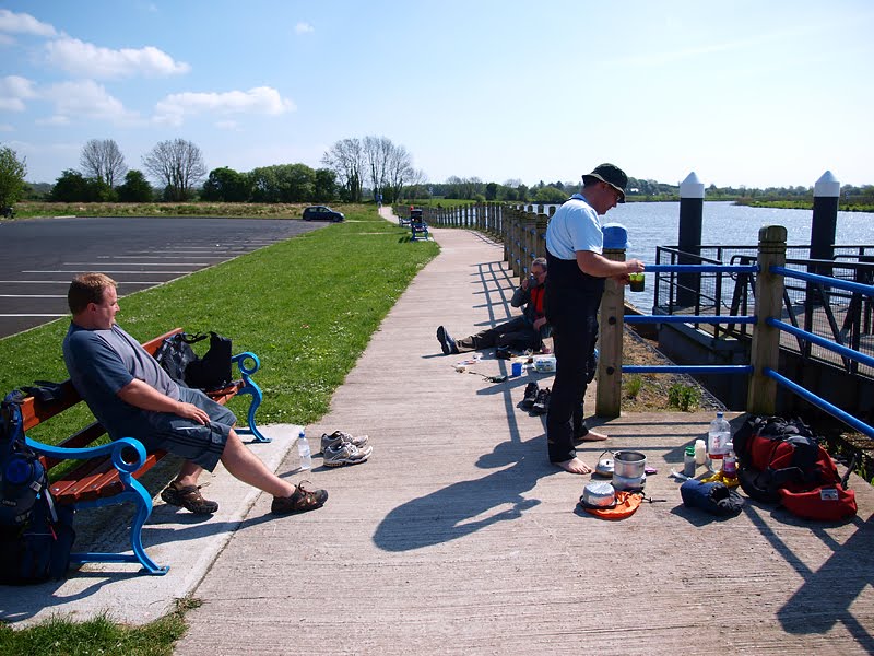
It wasn't long before Colin and Derek appeared so we decided to pool our resources for breakfast. With most of the camping kit stowed away we carried the cooking gear down to a picnic table near the jetty to prepare breakfast. Ralph using the Optimus Nova and the Eurohike frying pan made a start on the sausages and bacon while I started to fry up mushrooms, pancakes, potato bread and eggs. While the cooked breakfast was being prepared Colin and Derek boiled water for coffee and kept up a steady supply of cheese and salami. It was a bit tricky to synchronise everything so breakfast was eaten bit by bit as the various items became available eventually followed by some Kenyan ground roast coffee (I'd packed a cafetiere)


It was past 10.30am by the time the camps had been tidied up and left as found and the canoes and gear carried back down to the jetty. Already the temperature was high so water bottles were filled and stashed within easy reach before we set off towards the 1st of the 4 locks we had ahead of us.


The 1st lock, Portna was less than a a mile away and is reached by a short canal on the West bank avoiding the flood gates. On reaching the lock we checked the sign to see what the opening times were as the locks aren't attended continually.


According to the sign the lock should have been open from 10.30am but there was no sign of a lock keeper so we resigned ourselves to portaging around. Fortunately Portna is only a double lock but it would have been faster not to mention easier to have used the lock rather than having to portage. While we were getting sorted having portaged around to reach the jetty Ralph stopped to talk to a guy from the rivers agency, after a few phone calls it was arranged that the lock keeper would let us through the following 2 sets of locks at Movanagher and Carnroe.


It was about 11.30 when we set off again and after 1km we passed under the road bridge leading to the nearby town of Kilrea with 4km to go to the 2nd lock at Movanagher. It took us almost an hour before we entered the canal at Movanagher, this time on the East bank avoiding a weir so we tied up at the jetty while Ralph went to find the lock keeper. As it turned out the lock keeper couldn't be found although we did manage to find a guy who was working at the fish farm on the other side of the canal.


A few more phone calls to various departments failed to locate the elusive lock keeper but eventually contact was made. Of course by now we'd wasted half an hour and he was in Coleraine 20 or so km away and on his lunch break. Faced with a choice of portaging through with the assurance that he'd meet us at the 3rd lock, Carnroe 2 km away or waiting until after 2.00pm to get through the lock we were at we decided to portage again. The canoes were unloaded once again and after a few trips back and forth we were ready to go, one bonus was that we were able to replenish our dwindling water supply.

Although the next lock at Carnroe was only 2km away there seemed little point in rushing if there was going to be no one there until 2.00pm anyway so we sat about for a bit before setting off again.

We eventually arrived at Carnroe at almost 2.00pm and to our surprise the elusive lock keeper was waiting, wearing a red polo shirt I think the lock keeper may well be the Scarlett Pimpernell. Without stopping we paddled into the lock, Carnroe being a single and listened while the lock keeper offered advice on what we should have done i.e. let the appropriate body know that we were going to be "in the system", that failing to do so was "a bit silly", that they (who ever they may be) were "short staffed" and that it would have been "easier" if he'd known we were going to be needing to use the locks. Easier for us I assume as it could hardly have been any easier for him as he's thus far managed to open one set of lock gates while we'd carried around 4. There seemed little point in wasting time 'discussing' the situation, better to sit tight, say nowt and get on with it.


It was quite amusing though as we speculated on where he'd been and where he possibly should have been and whether he'd been disturbed by his employers after we called the head office (inadvertantly) to find out where he was. In the end I discovered that officially it's best to arrange to pass through the locks although it isn't mentioned on the Canoe trail guide. I found the information on the 'Waterways Ireland' website but it doesn't mention how much notice they need. In the end though it wasn't a big deal, it isn't like we had to portage around Neptunes Staircase on the Caledonia canal.

It only took 5 minutes or so to go through the lock and we set off again towards the next access point at Drumaheglis marina 7.5km away and from there the final 7km to the last lock of the day and indeed of the Bann itself at the Cutts, so named as the rock was cut away to form the channel allowing boats to continue on upstream. From the Cutts we'd only have a further 2km to go to reach our destination at Somerset Riverside Park, a total of 16.5km.

We had only been paddling for about 10 minutes after leaving the lock at Carnroe when we saw 2 kayaks heading towards us, it wasn't until they were right beside us that we realised they were another 2 guys from work. They had put in at Drumaheglis marina and were just out for a quick paddle up to the lock at Carnroe. We rafted up with them while drifting slowly downstream and chatted for a bit before they set off again upstream and we continued on our way. As we hadn't eaten since breakfast we decided to pull in at a shallow stretch for a late lunch.


It was now well past 3.00pm and while we were all suffering from the heat Derek was suffering more than the rest of us, not from the heat but from a sit-on-top that felt dead in the water and almost 5 hours effectively sitting in the water. With the prospect of a further 11.5km to go we reluctantly decided that we'd stop at Drumaheglis marina rather than continue to Somerset Riverside Park. Additionaly the next 6km or so were zoned for power boats so the decision was pretty much made to call it a day.


Ralph and myself reached Drumaheglis 1st but rather than tie up at the jetty which was busy with power boats we simply paddled up to the slipway and lifted the canoe out before returning to the slip to wait for the others. Although we were all on dry land we did briefly consider going a further 4km to the next access point at Camus but in the end decided against it. While Ralph went off to buy ice creams for us all Derek set about getting changed into dry clothes before phoning home to reorganise the pick up for himself, Colin and their 2 kayaks while I did the same for Ralph, myself and our canoe. We probably sat around for the best part of an hour before my wife arrived with my brother in law who was driving my car followed almost immediately by Dereks wife, strange that they should all arrive within minutes of each other as I only live about 10 miles away while Derek lives I'd guess about 35 miles away.

With everything loaded up we all set off and I guess we won't all see each other again until we go back to work. I definitely enjoyed it, it's over 20 years since I made the same trip and it's changed quite a bit since then, the facilities are much better, especially the new floating jetties and there's more activity, especially canoes/kayaks. Although we only saw 3 other canoes and 2 of them were guy we knew I can't remember seeing any others on the previous trip.

Obviously the weather being kind helped, had it been raining it would have been worse, perhaps not for Derek who was wet anyway but certainly for the rest of us. The winds when they were evident were light and on our backs and perhaps most surprising of all was that we weren't troubled by midges.

Friday, 29 April 2011

Lower Bann Canoe Trail, Day 1


I got back from the canoe trip on Thursday evening after 2 days of bright sunshine and intense heat. The trip was a good one but not without unforeseen problems that resulted in failing to reach our intended destination.


A late start on Wednesday morning meant we didn't leave the jetty at Toome until around 12.30pm but with scant regard for the 15 miles between us and the halfway point of our route we set off. Although we were going as a group of 4 we weren't operating entirely as a group nor were we operating as pairs and yet we weren't operating solo either. Cooking was something of a combined effort but only Ralph had a stove suited to group use in the form of the Optimus Nova and the only pan big enough to cater for 4 was the Millets non stick frying pan I'd received for review. I had the Backcountry Boiler and a Trangia 27k both of which are better suited to 1-2 person use and Derek and Colin had between them a disposable barbecue and an EK 750 woodstove, the EK 750 being a solo stove designed to use with an Alpkit Mitymug sized pot.

Although Derek and Colin had settled on their shelter by taking a tent Ralph and I changed our plans slightly and decided not to take a tent, Ralph provided 2 Hennessy Hammocks and also took a Belgian (I think) army bivvy bag and I took a TiGoat Ptarmigan bivvy and CCF mat in case we ended up camping in a spot with no suitable trees. The combined kit was something of a mixed bag which was to be expected as it was something of a 1st for us all and the final arrangements were made via text message/phone. Ralph who partnered me in the open canoe hadn't been in a canoe before and although Derek and Colin had canoed together before they hadn't undertaken a trip of this length/duration.


With the canoes loaded up the 1st thing that became apparent was that Derek's sit-on-top was quite low in the water due to a heavier than normal load, the result meant he was sitting in a few inches of water in the open 'self draining' cockpit, Colin had no such problem in his regular kayak while Ralph and myself took a little time to find our rhythm. With the sun shining brightly in a cloudless sky and with a slight following wind we left the canal passing the eel traps and soon slipped under the bridge towards Lough Beg.


Lough Beg is a nature reserve and is quite shallow apart from the actual navigation channel which is clearly marked, the West shore is mainly wetland which floods in winter. Church Island is also on the western side of the lough, the ruined church and spire dates back to the 18th century but the site was formerly a pre Viking monastery. Church Island isn't actually an island when the water level is low but like much of the western shore the low lying ground connecting it to the mainland floods in winter when the water level is higher. On this occasion we didn't visit Church Island due to time constraints but rather stayed on the eastern shore although we did stop briefly.


Shortly after leaving Lough Beg we stopped at the 1st official access point since leaving Toome. Newferry East and West has access on both sides of the river and we choose to tie up at the canoe jetty on the east bank to have lunch.

Although it's now a popular waterski venue (we didn't see any) there was an actual ferry across the river in the 1800's. The area around Newferry is designated as an area of special scientific interest due to the presence of Diatomite, used in the past in the production of gramophone records and dynamite, pretty versatile stuff then..


With lunch taken we set off once again and in an attempt to lighten the load and reduce the drag on the sit-on-top we took the waterproof barrel that Derek had been carrying. The next stretch was more interesting as as it wound it's way towards the village of Portglenone, home to Northern Ireland's only Cistercian Monastery. On this section there's quite a lot of woodland along the banks and rounding a bend we discovered a rather tired looking boat moored up under the overhanging bushes. A little further on the river passes through Portglenone forest and bluebells could be seen amongst the trees.


At yet another canoe jetty we stopped for a breather, we hadn't been stopped for long when a small powerboat approached slowed down and looked like it was going to come alongside, turned out it was another guy from work so we stopped and chatted for a bit. I noticed that there were some birch trees so collected some bark off one that had toppled over.


It was just past 5.00pm when we slipped underneath the bridge at Portglenone and with another 9km to go before we reached our intended stop we pressed on. It's probably fair to say we were all looking forward to setting up camp and getting a meal but for Derek on the sit-on-top there was an added incentive, with the canoe carrying a lot of gear and sitting low in the water the self draining cockpit had been flooded for the best part of 5 hours so he'd been more or less sitting in the water all day which I guess must have been pretty unpleasant.

Although it was cooler now energy levels were pretty low and we were glad to see the jetty come into view. With the canoes lifted out we began to look around for a decent spot to set up camp, the difficulty was in finding a spot that was equally suited to hammocks and a tent but in the end we found a spot amongst the trees that was clear enough to cook for the hammocks and another a few yards away that was reasonably flat and clear of brambles to set up the tent although unfortunately there was a high bank separating the 2.

Colin and Derek set up their camp and lit the barbecue while Ralph and myself set about getting the hammocks up and getting a meal under way. I'd brought a variety of food for the evening meal and in the end decided on 'Look What We Found' meatballs in a tomato and herb sauce with some Smash while Ralph prepared some rice, curry and sausage. I fired up the Backcountry Boiler using some of the birch bark I'd picked up earlier and a few twigs that were laying around and quickly boiled up some water for coffee while Ralph produced some tubs of fruit and custard which went down a treat.


With the evening meal over we walked up to the others to find that they'd had a couple of steaks on the barbecue and were using the still glowing coals as a base to build a campfire. Surprisingly although we could see and hear midges they were swarming around the treetops and we had no trouble from them at all. Not wanting to be outdone Ralph and myself went back to our camp to light a fire but having dug a shallow pit we didn't have quite as much success and were the subject of some ribbing from Derek and Colin.


We eventually all returned to our respective camps and while Ralph relaxed in his hammock I laid out my sleeping mat and leaned back against the upturned canoe with a cup of Starbucks Via instant coffee. At about 11.30pm I decided to turn in and shoved my sleeping bag, a Snugpak Premier 1 synthetic into the hammock. Although I was aware of potential heat loss due to a lack of insulation underneath I didn't bother to use my CCF mat which turned out to be a mistake. I hadn't previously used a hammock and as a side sleeper I was unsure how I'd fare but it was the cold that was the biggest problem.

While I was fine to begin with I only managed to doze and couldn't quite get over to sleep, I persevered until about 2.00am when a combination of cold and hunger had me out of the hammock and on the ground with the sleeping bag inside the TiGoat bivvy. After a chocolate bar I drifted off to sleep thinking of the sluice gates, flood barriers, weirs and locks not to mention the 24km that lay ahead of us.

Tuesday, 26 April 2011

Lower Bann Canoe Trail


I'm pretty much set for a 4 man/3 craft trip on the lower Bann canoe trail. Ralph and myself will be taking the Novacraft Prospector accompanied by another colleague from work and his mate using sit-on-top and closed deck kayaks respectively.

The Lower Bann Canoe Trail starts at Toome shortly after the river Bann exits Lough Neagh on it's way to the Atlantic. The trail is 58km although we'll be lifting out about 7km short for a variety of reasons not least ease of access for the pick-up the following day.

The river Bann as it runs from Lough Neagh to the sea forms the boundry between counties Antrim and Londonderry almost all the way, only swinging over to the Derry side as it nears the town of Coleraine. Points of interest along the way start with Toome itself, one of Irelands earliest hunter/gatherer settlements and within 200m of leaving the start point are the eel traps which are passed by staying to the East bank. From there on 4 sets of lock gates need to be navigated. Sites of historical interest stretch the length of the route dating from Mesolithic times to the present, the historical importance of the river Bann is evident.


The kit for this trip is quite different from the kit I'd take backpacking, space and weight are less important but as there's a strong possibility that the canoes will need to be portaged around the locks it's worth keeping things reasonably simple. That said some kit is being taken as a test simply because we can afford the extra weight. I'm taking the Vango Halo 200 but Ralph is also bringing 2 Hennessey hammocks which with any luck we'll get to use, I'm also taking the Alpkit Rig 7 tarp. Cooking is being taking care of with a selection of stoves between the 4 of us. Ralph is taking an Optimus Nova multi-fuel, I'm taking a Trangia 27k and Backcountry Boiler and and Derek is bringing an EK Kombi woodstove so cooking shouldn't be a problem. As far as sleeping kit goes I'm using a synthetic bag (Snugpak Premier 1) and a Millets CCF mat. As for food well that's going to be the main difference, rather than a selection of freeze dried/dehydrated food it'll be real food this time and a fry up in the morning is something to look forward to. As far as kit storage goes there were various options available but in the end we decided on a rucksack each with personal kit and a large water-resistant pack for food/tent/cooking gear etc. The large pack is from a lifeboat/liferaft and is the one I found washed up near the Giants Causeway last year.

Hopefully the weather will be kind, the midges will stay away and everyone will stay upright.


Wednesday, 18 August 2010

Wildcamp in the Antrim Hills


I managed to get another over-night wild camp last weekend but if the truth be told I wouldn’t have made it had it not been for the unexpected arrival of the MSR Reactor courtesy of Hendrik. It was a bit rushed even with a weeks notice as we’d been painting at home at the beginning of the week, I was working the end of week shift and I’d already planned something else for Saturday which was my 1st day off. In the end I juggled things around and planned with Marcus to set off on Saturday afternoon around 3.00pm. We arranged for Marcus’s sister to drop us off at Glenariff forest park with the intention of hiking up onto the plateau above Glenariff and setting up camp. We then intended to return to Glenariff on Sunday before continuing on over Trostan and Slieveanorra . From Slieveanorra it would be forest trails decending to the reservoir at Altnahinch where we were to be picked up.

I planned out a route using Quo mapping software and uploaded it to my Garmin Geko late on Friday night and gathered the rest of the kit together. I used the ULA Conduit which I’ve been happy with so far, again I took the Phreeranger with inner tent due to the threat of midges and my sleeping system consisted of the PHD Ultra Minim, full length CCF mat and the PHD Ultra Down vest as insurance. We’d had almost constant rain all week but with the forecast for Saturday/Sunday looking promising I once again took my Trespass Pack-Away Overtrousers and Marmot Essence Jacket. The plateau is really wet and boggy, the last time we’d been there was in December when it wasn’t too bad as the wetter areas were frozen, as then I decided on trail shoes, lightweight Karrimor Pro Run and Trekmates
Amphibian Gore-Tex socks. I had intended wearing a pair of ME Ibex softshell trousers but when Saturday dawned to bright sunshine and blue skies I opted for a pair of Columbia Omni trousers which are light and dry rapidly In the rush I couldn’t find my short sleeve Helly Hansen t -shirt so had to go with a long sleeve Sub Zero F1.


Day 1

The plan was to make a 10.5km hike to Knockore (WPT16) leaving from the roadside at the forest park (WPT001) and skirting the various loughs before crossing the stream near Lough fine (WPT011) where we intended to fill our water containers. The route was chosen to avoid the worst of the wet areas but to be honest the whole area is pretty wet.


We didn’t leave until 3.30pm and it was almost 4.00pm before we set off. It was very warm but we didn’t rush and I didn’t start the GPS until we left the park boundry at (WPT007)
We stopped briefly on the shoulder of Crockravar but didn’t stop for long due to midges, which unfortunately was an indication of things to come. As ever we didn’t follow the route exactly as we altered course here and there to avoid the really wet parts. We made steady progress in spite of the mixed terrain of heather and long grass and soon arrived at the stream (WPT011). We had stopped here in December to fill up on water prior to setting up camp on the side of a small rise about 200m NNE.


Surprisingly midges weren’t a problem and we sat around for about 10 minutes before setting off again, crossing a stile and continuing past our previous campsite and following the higher ground past Loughnacally towards Craigatinnel (WPT014) with it’s large cairn known as Turnlys seat. The top of Craigatinnel is reasonably flat with large flat rocky areas so as it was already after 6.00pm and I was getting hungry we decided to set up camp. The view was spectacular with the Irish sea just a few miles to the East and Scotland and the Galloway Hills in the distance . To the North West lay the Mull of Kintyre and to the North Islay and Jura with the Paps of Jura just visible through the haze. Our destination for the following day could be seen with Trostan on the other side of Glenariff and the summit of Slieveanora with it’s radio masts visible beyond, both to the North West , looking westwards the Glenariff mountain plateau stretched out , featureless save for a few of the loughs that remained unhidden and a few of the more prominent high points.

What should have been a perfect spot to sit around cooking a leisurely meal before watching the sun slip behind the hills was almost instantly turned into a trial by swarms of mountain midges. I seemed to be the choice target as although I’d applied some ‘Jungle Formula Family’ insect repellent which kept them from biting the sleeves and back of my t-shirt were covered in them. Marcus wasn’t receiving the same attention which was fortunate as he usually comes up in spots if bitten. Of course midges are annoying even if they aren’t biting so we both ended up wearing headnets and I even started wearing my waterproof jacket to keep them from getting through my t-shirt.

The actual purpose of the trip was of course to test the MSR Reactor and I’d brought along a part used 100g cartridge but Marcus who had intended using his meths stove realised that he’d forgotten to bring fuel. We weren’t too concerned as I was confidant having been testing the Reactor at home that we would have plenty of fuel. The MSR rapidly provided us with enough water and although eating was a fairly rushed affair it was welcome.


We found that walking around reduced the midge problem and as the temperature fell and a slight breeze got up the midges disappeared. I started to feel cold and pulled on the PHD Ultra Down vest and we sat around and were treated to a constantly changing display of colours as the sun finally slipped behind Trostan. A blanket of cloud draped itself over the hills on the coast and from our camp it looked lie a covering of snow. We eventually turned in at about 10.30pm and as I’d been on the go since 7.30am I soon fell asleep. I’d taken the PHD Ultra Minim but fell asleep still wearing the down vest and baselayer top. I wakened around 12.00am ate a chocolate bar and drifted back to sleep.

Day 2. Part 1


I wakened suddenly and instantly felt the heat of the sun, a quick check of my watch, it was 7.30am. I lay for a minute or two slowly coming back to life before the call of nature had me dressed and putting dry feet into wet shoes. It was pleasant just walking around, there was a slight breeze and the midges weren’t around and I took a few photos before Marcus’s head appeared from the porch of the Hike Lite.


With 27km ahead of us and not wanting to tempt either fate or midges we quickly set up our kitchen on a flat rock and fired up the MSR. In no time at all breakfast was being eaten and in good time as the breeze had disappeared to be replaced by the midges, no doubt hoping to have breakfast at my expense. Once again insect repellent was applied and headnets worn as the midges were really swarming as we packed our rucksacks. They were so bad that we didn’t remove our fleece tops until we were under way and then it was a case of getting the job done as quickly as possible.


Our intended route should have taken us back to the forest park by the shortest, straightest route but a desire to stay as high as possible and a need to replenish our water supplies meant that we deviated from the intended route. We kept going at a fairly steady and soon reached Lough Natullig where we were able to fill up with water which was filtered using an Aquagear filter bottle. Surprisingly the midges weren’t a problem so we were able to take our time before setting off again. We continued towards Crockravar but on a more northerly route than the previous day, the terrain was mixture of stony areas, peat bogs, heather and marsh, typical Antrim hills variety


It wasn’t long before we were back at the forest park where we hoped to have a rest and a snack at the coffee shop and it wasn’t until were almost at the visitor center that we met the 1st people we’d seen since leaving the park the previous day.

We spent more time than we’d intended at the picnic area but the weather was great and I treated myself to a carton of Orange juice, crisps and an ice cream with a chocolate bar stashed for later. We emptied out our water bottles and replaced the peat coloured water with cold clear water and set off on tarmac to start the next leg.

Day 2 Part 2


We soon left the park again and continued on a forest trail for a bit before crossing another road and entering the forest that covers the lower slopes of Trostan. The pace had been steady so when we reached the Essathohan waterfall we decided to stop for a few minutes before setting off up the south side of Trostan. I hadn’t been here since January when I came up with my XC Skis and I noticed that a few trees had fallen since then.


Once out of the forest we headed straight for the eastern side of Trostan but hadn’t gone far when something caught my eye. Unbelievably it was the remains of an old car. There wasn’t much left and clearly it had been there for a long time but although I’d passed it before, probably as close as 100m I’d never noticed it. The engine appeared to be missing, not that the presence of an engine would make getting a car into that position any easier as there’s nothing but soft peaty ground all around. It must have been a pretty large car as it had disc brakes at the front which would be unusual for a car of that age, it looked like at late 1960’s early 1970’s model. There was nothing to indicate what it was but I took a photograph of the front wing which might aid identification later. What really surprised me was the condition of the chrome on parts of the trim and the rear lights, it was as good as new so I guess they must have known something about chrome plating back then that has since been forgotten.


We continued up winding our way through the peat hags and although we had seen a car parked at the roadside we still hadn’t seen anyone on the hill. Before long we turned westwards and soon the summit cairn came into view where we met a couple with a young child. We stopped to chat but soon instead of midges we were faced with flying ants. I took responsibility for attracting them and moved off to set up the stove for what was to be our last stop of the day. As time was running out we’d decided not to take in Slieveanorra but simply to take the shorter route continuing along the forest track through Slieveanorra forest back to out pick-up point.


After a cup of soup and a coffee we packed up and started down the way marked trail towards the road. This was without a doubt the most unpleasant part as it was really muddy due to it being part of both the Ulster Way and the Moyle way. It was just a case of getting on with it as was just past 3.00pm and Marcus had already phoned to arrange the pick-up for 4.00pm. Once we reached the road we followed it for about 500m before entering Slieveanorra forest and the final few kilometres of forest trail to the reservoir at Altnahinch.


While it made a change to walk on dry firm trails the flying ants were a problem from time to time if only as they prevented us from stopping. We soon rounded the final corner and saw the gate a few hundred meters away, it was almost 4.00pm but we climbed the gate and set off down the final stretch of road and had only just reached the car park when Rosemary arrived, timed to perfection. A final photo was taken, packs placed in the car and we were on our way home.


It was a good outing even though we had to shorten it, the MSR Reactor proved to be extremely efficient if heavy. The midge problem was dealt with although I’d like a head net that worked better with a bush hat so that’s on the list of gear to get. I was glad I’d taken the inner tent even if it did mean carrying the extra 200g or so over the bivvy bag. The trail shoes were fine once again but unfortunately I think one of my Gore-Tex socks is leaking, wet feet wasn’t the problem as such although it rules out using my shoes in winter. The problem was that my wet sock must have creased up in the hollow between my big toe and the ball of my foot and was just starting to cause a blister. It didn’t matter as it only became noticeable on the last few hundred meters but if it had occurred sooner it might have been a problem. It’s something to consider now as we intend to have a weekend trip to the Cairngorms the last weekend in September/start October.